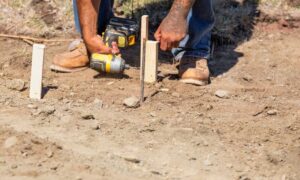
When storms hit San Diego this season, many homeowners saw the flooding, broken roads, and sinkholes all over social media. It looked shocking, but surveyors expected it. Heavy rain exposes weak ground, hidden erosion, and unstable soil. That is why LIDAR mapping has suddenly become more popular across San Diego. People want to understand what is happening under their properties, and they want clear answers before they build, remodel, or buy.
During big storms, water moves into the ground fast. It washes out soft soil, it shifts old fill dirt, and it weakens the support under streets, driveways, and yards. Some damage is visible, but most of it stays hidden. You may not notice anything at first, yet the ground may move slowly over weeks. That slow movement leads to cracks, dips, and flooding later on. Because of this, more engineers and surveyors rely on LIDAR to catch early warning signs.
Storms Exposed Hidden Problems
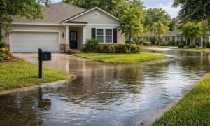
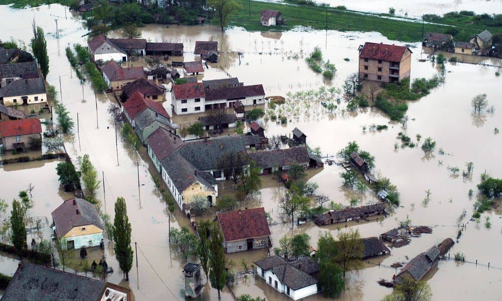
The recent storms reminded the whole city how fragile the ground can be. Roads collapsed in different neighborhoods. Driveways sank. Underground pipes failed. People shared videos online every day. Although it looked random, there were real reasons behind the failures.
San Diego has many older neighborhoods. It also has steep slopes, canyon edges, and coastal cliffs. Many homes sit on ground that changed over decades. Some properties were graded a long time ago, without today’s safety standards. Storms bring those problems to the surface.
Surveyors know rain reveals weak spots better than anything else. Water finds every gap, and it creates new ones. This season proved that again.
Why LIDAR Mapping Makes Sense Now

After this storm cycle, demand for LIDAR mapping rose fast. Homeowners want reliable information. Builders want accurate site conditions. Developers want risk reduced before projects begin. Everyone needs clearer data.
LIDAR gives surveyors a level of detail that normal field tools cannot match. It captures the exact shape of land down to inches or even less. It shows every rise and dip across a property, even in areas that look flat.
And unlike traditional tools, LIDAR works across large spaces quickly. It allows surveyors to scan entire blocks, hillsides, or canyon slopes within hours. There is no guesswork. There are no blind spots.
Even better, when used again later, it shows change over time. You can compare the land before a storm and after it. That comparison often reveals movement you cannot see with your eyes.
What LIDAR Mapping Helps Identify
Homeowners now use LIDAR mapping to learn:
- Where water collects on their lot
- Which parts of the property are sinking
- Whether soil is sliding slowly
- How slopes have changed
- Where ground settlement began
- If hardscape is shifting
- If drainage routes changed after storms
These details help prevent expensive mistakes.
Imagine planning a remodel, pouring a driveway, or adding a retaining wall. You assume your yard is stable. You believe the ground will hold. Then a year later, a crack forms. Water enters. Soil moves. The structure shifts. Suddenly, you face major repairs.
One LIDAR scan before construction could prevent all that.
What Homeowners Learned From the Storms
Many people dragged sandbags. Some homes flooded even though they never did before. A few homeowners saw their fences lean or separate after the rain. Others noticed new cracks in patios or walkways.
Those are not random problems.
They are symptoms of ground change.
And since San Diego weather continues to swing between drought and heavy storms, these problems will keep coming back. LIDAR mapping gives a foundation to respond early.
When you can see the ground shape clearly, you can plan repairs correctly. You can direct water safely. You can avoid damage. You stop guessing.
Why Surveyors rely on LIDAR after storms
Traditional measurement tools still matter, especially for boundaries. However, storms require more than simple measurements. They require a deeper look.
Surveyors prefer LIDAR after major rain because it allows:
- faster terrain analysis
- precise elevation detail
- drainage mapping
- comparison scans
- large coverage
- safer inspections
Steep yards become unsafe. Muddy hillsides slide. Erosion areas collapse without warning. LIDAR reduces the need to walk into risky zones.
More importantly, surveyors can then guide engineers, homeowners, and builders with confidence.
How LIDAR Helps Before a Remodel
San Diego has a surge of ADU construction, room additions, patio expansions, and new pools. Many people want to upgrade their homes right now.
After the storms, builders started requesting LIDAR data early in the planning process. They want to avoid pouring concrete onto unstable soil. They want to avoid placing structures in drainage paths. They want the safest layout possible.
LIDAR reveals the truth before money is spent.
And that protects everyone.
How LIDAR Protects Property Value
Land problems lower property value fast. Foundation repairs cost tens of thousands. Water damage spreads under flooring. Insurance often refuses coverage because ground movement counts as settlement, not flooding.
LIDAR helps homeowners:
- detect early issues
- fix problems before they grow
- document site conditions
- prove soil stability for lenders
- plan stronger drainage routes
The sooner ground issues are known, the easier and cheaper they are to fix.
When Should a Homeowner Consider LIDAR?
You should consider a LIDAR scan if…
- Your street flooded
- You saw road collapses nearby
- Your yard feels uneven now
- Water pools more than before
- You live near a canyon
- You plan to build
- Your yard is sloped
- You want peace of mind
The storms created change. Understanding that change matters.
Final Thought
Storm season shook San Diego. Many people woke up to a different version of their land. Some saw clear damage. Others sensed something shifted, but they could not explain it. Now, with better tools available, there is no need to guess.
LIDAR mapping helps homeowners see what storms left behind. It gives clarity, confidence, and direction. And most of all, it keeps small problems from becoming disaster stories online.
If you live in San Diego, the smartest move you make this year may simply be to understand the ground under your feet—before the next storm arrives.