Recently, San Diego made headlines after city officials filed a lawsuit against federal agencies over fencing placed near the border. The city claims the fencing crossed onto land it owns. Federal officials argue their work stayed within their authority. While the legal battle continues, one thing stands clear: this conflict centers on property boundaries. At the heart of disputes like this sits one critical tool — a boundary survey.
Now, this may sound like a government-only problem. However, it is not. The same rules that apply to city and federal agencies apply to homeowners, investors, and developers across San Diego. When ownership gets questioned, facts matter more than assumptions.
When Property Lines Turn Into Legal Lines
At first glance, land disputes seem simple. One party believes they own a piece of land. Another party disagrees. Yet in reality, land ownership involves layers of recorded maps, legal descriptions, and physical markers placed decades ago.
In San Diego, land records stretch back many years. Over time, roads shift, fencing moves, and land gets divided or combined. Because of this, the lines on paper do not always match what people see on the ground.
That is exactly where a boundary survey becomes powerful. It does not rely on guesswork. Instead, it connects legal documents to physical measurements taken in the field.
In the federal dispute, both sides will rely on official records. However, records alone do not settle the matter. A licensed surveyor must interpret those records and determine where the true boundary lies.
Ownership, Control, and Access Are Not the Same
Many people assume that if they control land, they own it. Yet that is not always true.
For example, a government agency may manage land without owning it. Likewise, a property owner may allow public access without giving up ownership. In addition, utility companies often hold easements that allow access but not full control.
Because these layers overlap, confusion grows fast.
A boundary survey clears up that confusion. It shows who owns the land, where it begins, and where it ends. It also shows recorded easements and rights that affect how the land gets used.
In high-value areas like San Diego, even a small strip of land can carry serious financial weight. Therefore, clarity protects both public and private interests.
How a Boundary Survey Becomes Legal Evidence
So, how does a boundary survey carry so much authority?
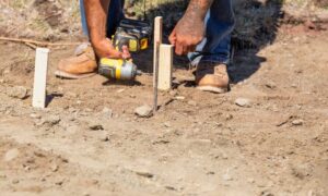
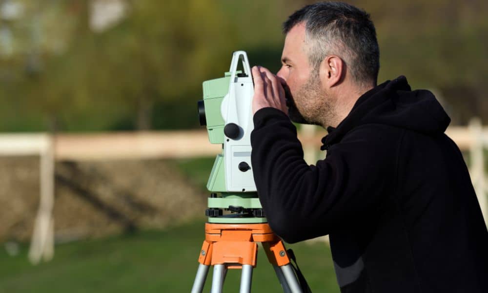
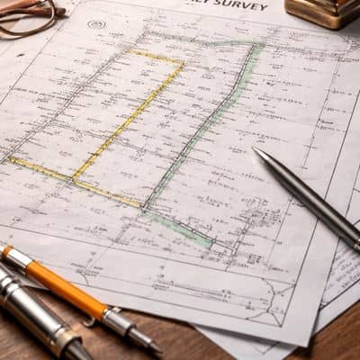
First, a licensed land surveyor researches the property’s history. That includes subdivision maps, deeds, and prior surveys. Next, the surveyor visits the site and searches for physical monuments — metal markers, concrete posts, or other evidence placed when the land was first divided.
Then, the surveyor measures the land using modern equipment. Finally, the surveyor analyzes all the data and prepares a certified map.
That certification matters. A licensed surveyor takes legal responsibility for the findings. Courts recognize this work as expert evidence. Because of that, a boundary survey does not represent an opinion. It represents a professional determination based on law, record, and measurement.
In large disputes like the one in San Diego, that level of proof can shape the outcome.
Why Assumptions Create Expensive Problems
Even government agencies can rely on outdated maps or digital layers that do not match real-world conditions. Likewise, private property owners often rely on fences, landscaping, or online maps.
However, those sources do not define legal ownership.
Digital mapping tools help with planning. Yet they cannot replace field verification. Over time, small errors grow larger. As land values rise, those small errors turn costly.
In San Diego, land sits at a premium. Therefore, even a few feet of disputed property can affect development plans, infrastructure projects, or long-term investment decisions.
A boundary survey stops that uncertainty before it grows.
What This Means for Property Owners
You may not face a federal lawsuit. Still, you may own land next to public property, utility corridors, canyons, or transportation routes. In those cases, boundaries matter more than ever.
For example, commercial properties near public land often require precise documentation before improvements begin. Investors also need clear boundaries before buying or refinancing property. Lenders and title companies prefer certainty as well.
Furthermore, properties located near parks, rail lines, or coastal access areas often involve layered rights and recorded agreements. Without a verified boundary, those layers create confusion.
Although the federal dispute involves large agencies, the lesson applies to everyday property decisions. Clear boundaries protect your position long before conflict begins.
Financial Stakes Go Beyond the Dispute
San Diego’s real estate market moves quickly. Buyers expect clean records. Lenders want accurate documentation. Developers require precise site data.
When ownership becomes unclear, transactions slow down. In some cases, deals collapse. In others, redesign costs rise.
On the other hand, a current boundary survey strengthens your position. It shows that your property aligns with recorded documents. It also supports future planning and protects value.
Therefore, while some view surveys as optional paperwork, they actually serve as risk management tools.
Why Working With a Licensed Surveyor Matters
Not all measurements carry legal weight. Only a licensed land surveyor can determine property boundaries.
That license represents education, testing, and state regulation. More importantly, it means accountability. A licensed professional must follow strict standards and carry liability for the work performed.
In a place as complex as San Diego, local experience also plays a role. Historic subdivisions, layered public records, and high-density development demand careful interpretation.
A boundary survey completed by a qualified professional gives you defensible documentation — not just lines on a map.
The Bigger Lesson From San Diego’s Dispute
The current federal conflict may take time to resolve. However, it already teaches a clear lesson. Land ownership requires proof. Assumptions fail under scrutiny. Documentation wins.
When property lines become unclear, tensions rise. Yet when boundaries get verified, decisions move forward with confidence.
A boundary survey does more than mark corners. It defines rights. It supports legal authority. And it protects value in a competitive market.
If you own property, especially near public land or shared corridors, clarity should come first. By investing in a boundary survey early, you avoid costly surprises later.
After all, when land becomes the subject of a headline, the strongest position belongs to the party with clear, certified boundaries.