Buying or owning property can feel straightforward at first. You check the price, the location, and the condition of the home. Everything seems fine. Then suddenly, someone mentions a FEMA elevation certificate, and things get confusing. At that point, most people start wondering why a FEMA elevation certificate might be required in the first place.
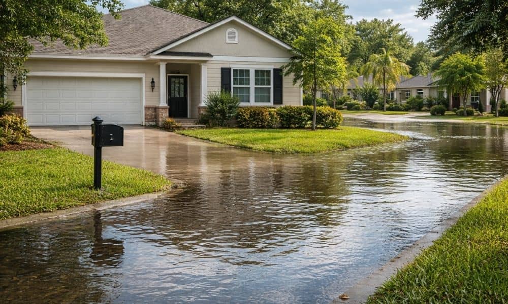
Many property owners are hearing about this for the first time. That is happening because San Diego recently updated its flood maps. Even though your home may look the same, the way it is classified may have changed. Because of that, lenders, insurers, and city offices are asking for new information.
So instead of guessing, it helps to understand how to check if you actually need a FEMA elevation certificate. The good news is that the process is simple when you break it down.
Why San Diego Property Owners Are Being Asked for a FEMA Elevation Certificate Now
San Diego’s flood maps change over time. Engineers study rainfall, drainage systems, and land elevation. Then they update flood zones based on new data. Because of this update, some properties are now inside areas that carry higher flood risk.
This shift does not always match what you see on the ground. Your home may have never flooded. Still, the updated classification can trigger new requirements. That is why more homeowners, buyers, and builders are now being asked for a FEMA elevation certificate.
In other words, the request is not always about past flooding. Instead, it is about how your property fits into the latest flood data.
Who Should Pay Attention to the Flood Map Update
Not everyone needs to act right away. However, certain situations make this much more important. For example, buyers under contract often run into this during loan approval. At the same time, homeowners who want to refinance may face the same request.
In addition, people planning construction or home improvements should pay close attention. Properties near the coast, rivers, or low-lying areas often fall under more scrutiny after a map update.
Because of this, it helps to take a moment and ask yourself: could this affect my property right now? If the answer is yes, you’ll usually start to see when a FEMA elevation certificate is needed as you move forward with things like financing, insurance, or permits.
How to Check If Your Property Is Affected by the Flood Map Update
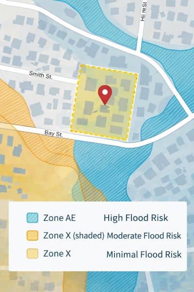
The first step usually starts online. FEMA provides a map tool where you can search your address and view your flood zone. Once you see your property on the map, you can tell whether it falls inside a marked flood area.
However, that is only part of the picture. What matters just as much is whether your property’s status has changed. For example, if your home used to be outside a flood zone and is now inside one, that change can trigger new requirements.
At the same time, local San Diego data can give more detail than FEMA maps alone. Sometimes, these two sources do not line up perfectly. When that happens, confusion is common. Still, that confusion is often the moment when a FEMA elevation certificate becomes necessary.
Finally, lenders and insurance providers play a big role. Even if the maps look unclear, they may still require official documentation before moving forward. Because of that, it always helps to confirm directly with them.
Signs That You May Need a FEMA Elevation Certificate
Sometimes, the need for a FEMA elevation certificate becomes obvious. Other times, the signs are subtle. For example, you may notice that your insurance quote suddenly increases. In other cases, your lender may request documents you have never heard of before.
You might also run into issues when applying for a building permit. Even small projects can trigger questions about elevation and flood risk. On top of that, conflicting information between online maps and real estate listings can create even more uncertainty.
When these signs appear, it usually means your property needs closer review. Instead of ignoring them, it is better to take action early.
Why Online Maps and Listings Can Be Misleading
Many people rely on real estate websites and map apps when researching property. While these tools are helpful, they often do not reflect the most recent flood data. Because of that, they can give a false sense of security.
For example, a listing may say the property is outside a flood zone. However, the updated maps may show something different. At the same time, map boundaries are not always exact when it comes to structure elevation.
Because of this, relying only on online tools can lead to surprises later. That is why accurate elevation data matters when decisions become serious.
When a Licensed Land Surveyor Becomes Important
At some point, checking maps is no longer enough. When that happens, a licensed land surveyor can step in and provide clear answers.
A surveyor measures the exact elevation of your structure and compares it to flood levels. Then they prepare the official documentation needed for lenders, insurers, or permit approvals. This process removes uncertainty and gives you reliable information.
More importantly, it helps you avoid mistakes that could delay your plans or increase your costs.
What Happens If You Wait Too Long to Check
It can be tempting to put this off, especially if nothing seems urgent. However, waiting can lead to bigger problems. For example, a home closing may get delayed while documents are being sorted out. In other cases, insurance costs may rise without warning.
Construction projects can also run into trouble. If elevation issues show up late, plans may need to change. That can lead to extra time and added expenses.
Because of this, checking early is always the safer move. It gives you time to respond instead of reacting under pressure.
What to Do Next If You Are Unsure
If you are not sure whether you need a FEMA elevation certificate, start with a simple review of your property on FEMA maps. Then take a closer look at local San Diego data and compare any changes.
After that, reach out to your lender or insurance provider. They can confirm whether documentation is required. If things are still unclear, working with a licensed land surveyor can give you a clear answer.
By taking these steps, you stay ahead of potential issues. More importantly, you avoid delays that can affect your plans.
Final Thoughts
San Diego’s flood map update has changed how many properties are evaluated. Even if your home looks the same, the rules around it may have shifted. Because of that, checking whether you need a FEMA elevation certificate is now more important than ever.
The process does not have to be complicated. With the right steps and the right information, you can move forward with confidence. In the end, a small effort today can prevent much bigger problems tomorrow.