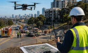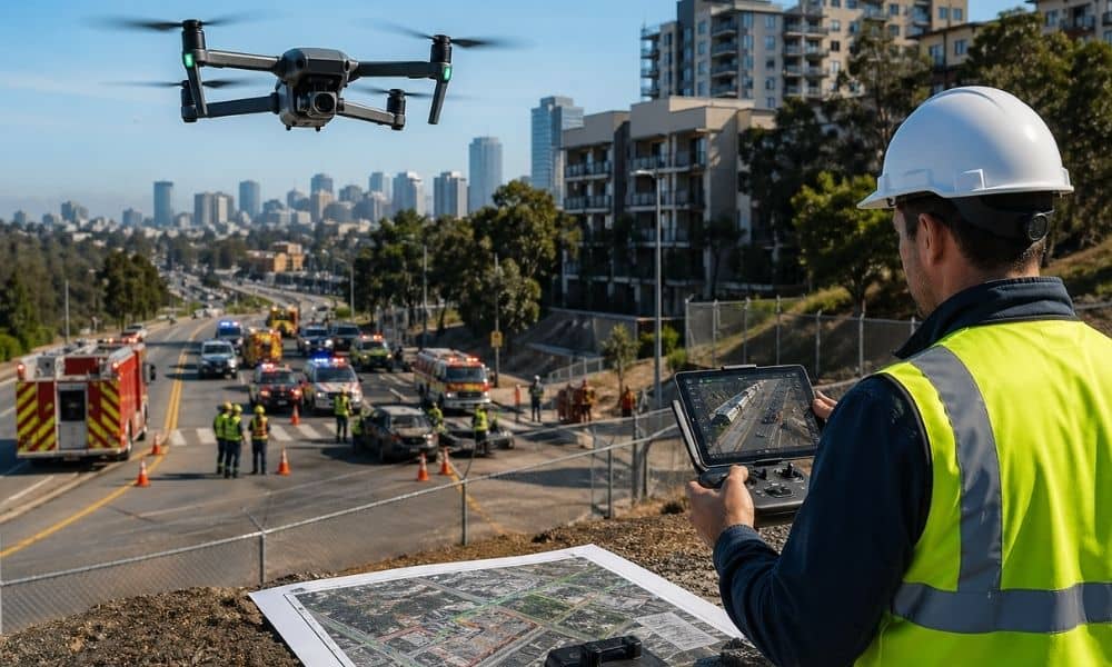
San Diego is starting to use drones in a way that goes beyond photography or construction updates. These systems now play a direct role in emergency response. When something happens in the city, drones can reach the scene faster than ground teams and send live information back to command centers.
This shift is changing expectations around aerial data. It also affects how a drone surveyor works in the same environment, especially when accuracy and timing both matter.
How San Diego is using drones during emergencies
The drone first-responder program allows drones to launch quickly during incidents like traffic accidents, fires, and coastal emergencies. Instead of waiting for full response teams to arrive, a drone can give an immediate view of the situation from above.
This helps emergency teams understand what is happening in real time. Roads, buildings, and terrain can be assessed faster. Decisions can be made sooner because the visual information arrives early.
In a city like San Diego, where terrain changes quickly between coastal zones, urban areas, and hillsides, this speed matters.
Why this changes expectations for aerial data
Even though the program focuses on emergency response, it changes how people think about aerial information in general.
More people are now exposed to fast drone footage. That includes developers, engineers, and property owners who work with land every day. As a result, there is a growing expectation that aerial data should always be quick and easily available.
But speed does not always mean usability. Emergency drone footage is designed for awareness, not for engineering decisions.
That is where the difference becomes clear between emergency mapping and professional surveying work.
The role of a drone surveyor in this new environment
A drone surveyor works in a different way compared to emergency drones. Emergency systems focus on fast visuals. Survey work focuses on precision.
A drone surveyor collects measured data from a site and turns it into maps that can support construction, planning, and land development. The goal is not just to see the land but to measure it accurately.
In San Diego, this becomes even more important because land conditions vary a lot. Coastal areas, steep slopes, and urban developments all require accurate elevation and positioning data.
Emergency drones may show what a site looks like after an incident. A drone surveyor determines what that means for actual land use and construction.
Why fast drone data is not enough for construction decisions
Emergency drone systems give immediate visuals. That is useful for response teams. However, construction and land development require more than visuals.
Even small errors in elevation or distance can affect how a project is built. Roads, drainage systems, and building foundations all depend on accurate measurements.
This is why survey-grade drone work still matters. It provides data that can be trusted for design and construction.
Fast information helps people see the situation. Accurate survey data helps people build on it safely.
How this shift is affecting real projects in San Diego
As drone use becomes more common in emergency response, expectations for aerial data are rising across other industries.
Developers and property owners now see aerial information more often and earlier in project planning. This can create the impression that site data should always be immediate.
But survey work still requires careful steps. The data must be collected, processed, and verified before it can be used in design or construction.
This gap between fast visuals and usable data is where misunderstandings often happen.
Why drone surveying is becoming more important, not less
The rise of emergency drone systems does not reduce the need for surveyors. It increases it.
Emergency drones show what is happening on the ground. Drone surveyors provide the accurate measurements needed to make decisions based on that information.
For example, after a fire or accident, emergency drones may show damage or blocked areas. A drone surveyor can help translate that into usable site information for rebuilding or redevelopment.
Both systems support each other, but they serve different purposes.
What this means for land development and planning
For anyone working with land, this shift changes how early decisions are made.
More aerial information will be available faster than before. However, not all of it will be suitable for engineering or construction.
Accurate surveying is still needed before any major work begins. Without it, even good-looking data can lead to incorrect assumptions about a site.
This is especially important in areas with complex terrain, where small measurement differences can affect major design decisions.
The bigger shift happening in how cities use drones
San Diego’s drone first-responder program is part of a larger change in how cities operate. Drones are becoming part of daily infrastructure, not just tools for specific industries.
As this continues, aerial data will become more common in public systems. But the need for verified, survey-grade information will remain.
The more drones are used for quick responses, the more important accurate surveying becomes behind the scenes.
Final perspective on drone surveyors
The rise of emergency drone systems is changing how people view aerial information. Data is now available faster and more often than before.
But speed alone is not enough for land development or construction.
A drone surveyor still plays a key role by turning aerial information into accurate, usable measurements. In a city where drones are now part of emergency response, that accuracy becomes even more important.
Emergency drones show what is happening. Drone surveyors make sure people can build from it correctly.