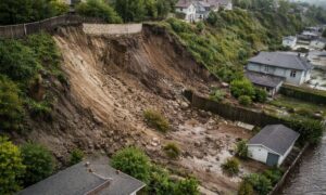
When a scaffold suddenly collapsed at a busy job site in San Antonio last week, it made national headlines. Roads were blocked, emergency teams rushed in, and engineers spent hours figuring out what went wrong. It wasn’t just a story about construction—it was a reminder of how fragile a project can be when accuracy slips. For developers, it’s a wake-up call to treat every layout, stake, and line on the ground with care. That’s where an ALTA survey comes in—it’s more than paperwork; it’s your first layer of protection before a single scaffold rises.
When small errors become big problems
Construction failures rarely happen because of one big mistake. More often, it’s a mix of small oversights that build up over time. A control point is ignored, a boundary line isn’t verified, or an old map is used instead of the latest site data. By the time crews start setting forms or assembling scaffolding, the work is already off by inches. Those inches matter.
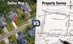
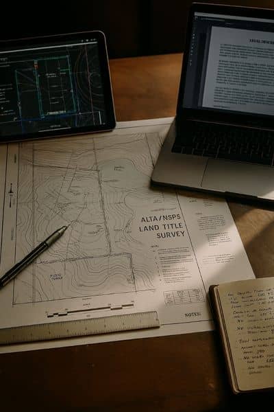
An ALTA survey is designed to prevent this. It maps every boundary, easement, and encroachment based on both field measurements and title records. It’s the foundation that keeps architects, engineers, and contractors aligned—literally. Without it, one team might be working off assumptions while another follows outdated plans. That’s how projects drift from accurate to risky.
The truth about how layout mistakes start
Most construction errors don’t happen in the design phase; they happen on the ground. A contractor sets stakes from an old plan. A survey crew isn’t called back to re-check control after grading. Or someone assumes a parcel boundary hasn’t changed when it actually has. Once the site work begins, everyone moves fast, and that’s when layout errors get buried under concrete.
Developers know how costly that can be. The city’s tight parcels, narrow setbacks, and mixed zoning mean there’s little room for error. A wall that sits a foot over a boundary or a footing that crosses a setback can delay permits or require a complete redesign. Every fix costs time, and every delay costs money.
With an updated ALTA survey, you avoid those surprises. It verifies that the design drawings match the property’s actual legal limits before construction staking even starts. That single step can save weeks of frustration and thousands of dollars in rework.
Why the ALTA survey isn’t just for closings
Too many developers treat the ALTA survey as something that’s only needed during the purchase or financing stage. Once the deal closes, the survey often gets filed away. But that document should stay alive through every stage of construction.
The same control points shown on the ALTA map form the backbone of your project’s staking and as-built records. If contractors or subs ignore it, they risk working from the wrong base data. That’s when problems show up later—when inspections fail or when scaffolding leans where it shouldn’t.
In San Diego’s dense neighborhoods like North Park, Hillcrest, or East Village, a few inches of misalignment can lead to encroachments or structural conflicts. When multiple buildings share tight spaces, even a misplaced temporary structure can block access or violate code. Keeping your ALTA survey active throughout construction ensures every stake, footing, and scaffold matches the approved layout.
San Diego’s extra layer of complexity
San Diego is not an easy city to build in. Parcels are often stacked or split for condominiums, meaning one lot can have several legal descriptions beneath it. The city’s Grading Permit standards require precise topographic data and strict setback verification. Add in the steep slopes, coastal zones, and layered zoning codes, and it’s clear why accuracy is non-negotiable.
That’s where ALTA surveys prove their worth. They combine ground data with recorded title information to show how a site’s physical and legal boundaries actually meet. Before any excavation or staking happens, developers can see where easements, utilities, and property lines truly fall. When that information feeds directly into the layout process, it prevents costly conflicts down the line.
If you’ve ever dealt with a delayed grading inspection or a permit resubmittal because of a “minor” map error, you already know how critical this step is. San Diego inspectors expect documentation that matches what’s in the field—and the ALTA survey is your best guarantee that it will.
Keeping teams aligned from start to finish
Even the best design team can fail if communication breaks down in the field. Construction schedules move fast, and sometimes crews rely on verbal instructions instead of verified control points. The fix is simple but powerful: keep the surveyor involved beyond the start of the project.
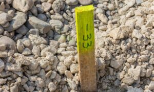
Have your ALTA control points re-checked after grading, before scaffold setup, and again before major pours. Create a quick “stake log” that tracks which markers were verified and when. Encourage foremen to take daily photos of those markers. It’s a small habit that prevents massive confusion later.
When every crew—from concrete to framing—references the same ALTA base map, layout conflicts drop dramatically. There’s no guessing which boundary to trust or which corner to measure from. Everyone works from one source of truth, and the project stays on track.
What happens when you don’t verify
Imagine a mixed-use project downtown where contractors begin work based on an old survey from a previous owner. The staking crew doesn’t realize the parcel was re-subdivided last year, and one scaffold line sits a few feet into an adjacent lot. It’s not noticed until the building inspector flags it. The developer now faces delays, redesigns, and liability for trespassing on another property.
That scenario isn’t rare—it happens more often than most builders admit. The cost of re-surveying and rebuilding far outweighs what it would have taken to verify the ALTA data at the start. And in dense cities like San Diego, those mistakes don’t just slow progress; they can damage reputations and strain lender relationships.
Turning accuracy into a habit
Precision doesn’t have to be complicated. Before breaking ground, confirm that your design team, civil engineer, and surveyor are all using the same ALTA survey file. Make it part of your construction safety checklist, right next to permits and insurance. If the project scope changes or the grading plan is revised, call your surveyor back to update the control data.
Doing this doesn’t just prevent mistakes—it builds trust. Inspectors see organized documentation. Lenders see consistency. And your crew sees that accuracy is valued as much as speed.
The bottom line
The San Antonio scaffold collapse showed how quickly a project can go wrong when the groundwork isn’t solid. In San Diego, where parcels are tighter and regulations tougher, precision is everything. The ALTA survey isn’t a formality—it’s your project’s anchor.
Before scaffolds rise and concrete cures, double-check your base data. Keep your surveyor close, your control points protected, and your documentation current. Because the best way to build safely—and finish on time—is to start from the right foundation.