How a Boundary Survey Can Decide a Land Dispute
Recently, San Diego made headlines after city officials filed a lawsuit against federal agencies over fencing placed near the border. The city claims the fencing
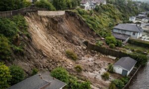
Why Aerial Survey Demand Surges After Storm Damage
San Diego just went through another round of heavy rain, flood alerts, and coastal erosion warnings. For a few days, everyone talked about road closures
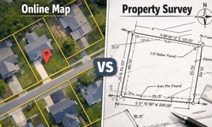
Why Your Property Survey Doesn’t Match Online Maps
Many people look at online maps and assume the boundary lines they see must be correct. After all, the image looks detailed. The parcel lines

Why Boundary Line Surveys Are Suddenly in the Spotlight Now
If you follow local news or neighborhood forums in San Diego, you may have noticed a pattern. More stories now involve property lines, permit disputes,
How a Construction Staking Survey Stops Costly Re-Work
Construction mistakes rarely start with bad intentions. Most begin with small layout assumptions that snowball into expensive re-work once construction is already underway. In San

Why FEMA Declarations Drive FEMA Elevation Certificate
When FEMA announces a disaster declaration, most people think about emergency help and cleanup. However, for property owners, the effects often go much further. A