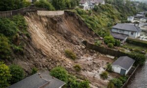
Building on a sloped lot looks great on paper. In real life, however, slopes turn small mistakes into expensive problems fast. That’s where a construction staking survey becomes essential. Within the first days on site, this survey sets the exact locations and elevations that guide every step of construction. When it’s done right, it protects your budget, your schedule, and your approval timeline.
Sloped terrain, tight setbacks, and dense neighborhoods make San Diego one of the toughest places to build accurately. Because of that, precise staking isn’t a luxury. It’s risk control.
Why sloped lots magnify construction errors
On flat ground, a few inches might not seem like much. On a slope, those inches can turn into feet of vertical error. As a result, a foundation can end up too high, too low, or too close to a property line. Then inspections fail. Crews stop. Costs climb.
Moreover, San Diego’s zoning rules leave little room for error. Setbacks protect neighbors, utilities, and coastal views. When a building footprint crosses those limits, even slightly, fixes cost far more than prevention.
That’s why builders rely on accurate staking early. It translates plans into the real world before concrete, grading, or walls lock mistakes in place.
What a construction staking survey actually does
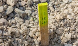
Many people think staking just means placing a few wooden stakes. In reality, a construction staking survey does much more. It sets the precise horizontal and vertical positions for:
- Building corners
- Finished floor elevations
- Setback lines
- Retaining walls and slopes
Because slopes change elevation quickly, vertical accuracy matters as much as horizontal location. Therefore, surveyors must control both with care.
Most important, staking connects approved plans to the land itself. That connection keeps construction aligned with permits and design intent from day one.
Why GPS alone struggles on sloped urban sites
Modern surveyors use GPS often, but GPS doesn’t solve every problem. In urban areas with hills, signals can weaken or bounce. Trees, buildings, and retaining walls block satellites. As a result, vertical readings drift.
On a sloped lot, that drift can push a foundation out of tolerance. Even when horizontal points look right, elevations can be off just enough to cause grading failures or drainage issues.
Because of these limits, experienced surveyors avoid relying on GPS alone for construction staking on slopes.
The hybrid approach that improves staking accuracy
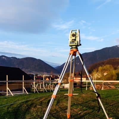
To handle slopes correctly, surveyors combine tools. They use GPS where it performs best and total stations where precision matters most.
First, surveyors establish strong control points. They place them in open areas with clear sky views. GPS works well here. These points create a reliable reference frame for the site.
Next, surveyors switch to total stations in tighter areas. Total stations measure angles and distances with high accuracy. They perform well near buildings, walls, and steep grade breaks.
By blending both tools, surveyors maintain accuracy across the entire site. As a result, stakes reflect real conditions, not just ideal ones.
How surveyors verify data before staking
Before stakes go in the ground, surveyors check their data carefully. They combine GPS and total station measurements in professional software. This step confirms that elevations match across control points and that angles close correctly.
Because slopes amplify errors, these checks matter. A small mismatch can lead to a large vertical mistake downhill. By catching issues early, surveyors prevent costly corrections later.
For clients, this process stays invisible. Still, it’s one of the main reasons a construction staking survey protects your project.
Common staking mistakes on sloped lots
Even good plans fail when staking goes wrong. On sloped sites, a few mistakes show up often.
Some crews assume elevations instead of verifying them. Others place control points too close to slope breaks. In some cases, surveyors rush setup and skip redundancy checks.
These shortcuts lead to serious outcomes. Foundations miss grade. Setbacks get violated. Drainage slopes reverse direction. Then fixes require redesign, rework, or legal review.
Fortunately, a careful staking process avoids all of this.
How proper staking protects your budget and timeline
Construction delays cost more than survey fees ever will. When stakes are accurate, crews build with confidence. Inspections pass on the first visit. Work flows from grading to framing without pause.
In addition, clear staking reduces disputes. Builders, inspectors, and owners see the same reference points. That shared clarity keeps everyone aligned.
For homeowners, this means fewer surprises. For developers, it means predictable outcomes. Either way, the value shows quickly.
When to schedule a construction staking survey
Timing matters as much as accuracy. Schedule staking before grading begins. Then update stakes before foundation work. On sloped sites, extra checks before retaining wall construction help as well.
By involving surveyors early, you avoid reacting to problems later. That proactive step saves time and money.
Why staking is risk management, not an extra cost
On sloped lots, gravity never takes a break. Water flows downhill. Loads shift. Small layout errors grow fast. A construction staking survey stands between your plans and those risks.
Instead of fixing mistakes after the fact, staking prevents them from happening. It keeps grades correct, setbacks clear, and inspections smooth.
In the end, accurate staking doesn’t just mark the ground. It protects your entire project from avoidable setbacks and rising costs.