San Diego is changing fast. New housing rules, tighter zoning reviews, and louder public input now shape how land gets approved. As a result, ALTA title surveys are showing up earlier and more often in real estate deals. Buyers, lenders, and developers want clarity before projects face delays. And right now, clarity matters more than ever.
Over the past few days, San Diego City Council decisions around land use and infrastructure have sparked public debate. These discussions may not mention surveys by name. Still, they raise questions about access, rights, and boundaries. When land use becomes public, documentation standards rise. That shift explains why ALTA title surveys are moving from “nice to have” to “must have.”
Land Use in San Diego Is Under a Brighter Spotlight
San Diego no longer treats land decisions as quiet paperwork. Today, projects draw attention from residents, planners, and the media. Infrastructure placement, zoning changes, and approvals now happen in public view. Because of that, assumptions no longer pass unnoticed.
At the same time, community feedback carries more weight. When neighbors raise concerns, reviewers slow down and look closer. They ask better questions. They also expect better answers. In this environment, clean documentation helps projects move forward with confidence.
Zoning Decisions Change the Risk Picture
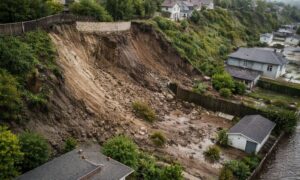
Zoning updates affect more than building height or density. They change how land fits into the city’s long-term plans. For example, a site near shared corridors or public access points may face new reviews. Even if the plan looks solid, uncertainty can creep in.
Because of this, approval teams look for proof. They want to confirm access rights, recorded uses, and boundary alignment. When records match reality, decisions move faster. When they don’t, deals stall. That pressure pushes teams to request ALTA title surveys earlier in the process.
Public Debate Raises the Bar for Due Diligence
Recent council actions show how land and policy now overlap. Discussions about infrastructure placement, data use, and public space highlight a simple truth: land connects many interests. When more voices enter the room, risk tolerance drops.
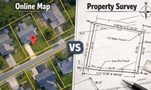
Therefore, lenders and attorneys adjust. They reduce gray areas. They ask for documents that align title records with what exists on the ground. ALTA title surveys meet that need because they connect legal descriptions to physical conditions in one clear report.
Why ALTA Title Surveys Fit This Moment

In a policy-driven environment, timing matters. Teams no longer wait until the end to confirm details. Instead, they verify early to avoid rework later. ALTA title surveys support that shift.
These surveys help confirm legal access when projects sit near public land. They also clarify recorded rights that affect approvals. Most important, they support title review when land use decisions face questions or objections. That support keeps deals steady even when scrutiny increases.
Real San Diego Scenarios Where This Applies
Consider an infill project near a busy corridor. The plan meets zoning rules, yet public comments raise access concerns. Reviewers ask for proof that the site’s access aligns with recorded rights. An ALTA title survey provides that proof and keeps the project on track.
Now think about a redevelopment with layered approvals. Older records exist, but recent zoning changes add complexity. By ordering an ALTA title survey early, the team aligns title and site data before reviews begin. As a result, the approval process runs smoother.
Finally, imagine a commercial purchase near shared infrastructure. Lenders worry about exposure if records lack clarity. An ALTA title survey answers those questions upfront, which protects timelines and financing.
Why Requests Are Happening Earlier Than Before
Traditionally, teams ordered surveys near closing. Today, many request them during early due diligence. This change reflects a new reality. When projects face public review, delays cost more than surveys.
Early surveys help teams identify issues before they become obstacles. They also reduce last-minute title exceptions that can derail deals. In San Diego’s dense market, this approach saves time and stress.
What This Means for Buyers and Developers
If you plan to buy or develop land, expect higher documentation standards. Public visibility and zoning changes will continue. Because of that, preparation matters.
Order ALTA title surveys early, especially when projects touch shared spaces or complex approvals. Work with professionals who understand local review patterns. Most of all, treat documentation as a strategy, not a formality.
The Bigger Picture: Visibility Changes the Rules
San Diego’s growth brings opportunity. It also brings attention. When land use becomes visible, clarity replaces assumption. Projects that plan for scrutiny move forward with fewer surprises.
ALTA title surveys support that clarity. They help teams navigate policy shifts with confidence. And in a city where land decisions matter to many people, that confidence keeps deals moving.
In the end, development will continue. Zoning will evolve. Public voices will grow louder. Through it all, strong documentation remains the foundation. By using ALTA title surveys at the right time, buyers and developers can stay ahead of change and keep their projects on solid ground.