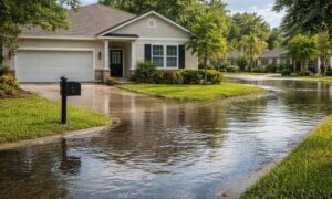
San Diego just went through another round of heavy rain, flood alerts, and coastal erosion warnings. For a few days, everyone talked about road closures and damaged neighborhoods. Then the skies cleared. Life moved on. However, the land does not reset that quickly. After major storms, the ground continues to shift. Soil settles. Drainage patterns change. Slopes absorb more pressure than before. Because of that, demand for an aerial survey has increased across San Diego in recent weeks.
Property owners want to know what changed. Developers need updated site data. Engineers need proof before they sign off on repairs. Right now, an aerial survey gives them that clarity.
Storms Don’t Just Damage Buildings — They Reshape the Ground
When people think about storm damage, they picture broken fences or flooded garages. Yet the real risk often hides below the surface.
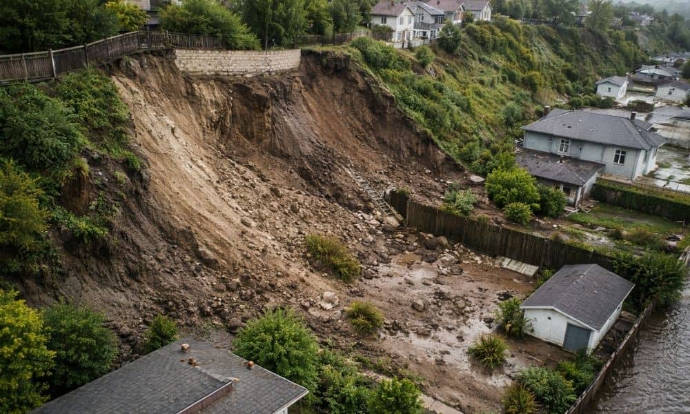
Heavy rain saturates soil. As the soil fills with water, it becomes heavier and weaker. On hillsides, gravity pulls that weakened soil downhill. Even small movements can shift grading around foundations or retaining walls. You might not notice anything at first. Still, the land may already be under stress.
At the same time, fast-moving water cuts new drainage paths. It erodes certain areas and deposits sediment in others. Because of that, water may flow differently the next time it rains.
In San Diego, where hills, canyons, and coastal bluffs shape many neighborhoods, those changes matter. A few inches of soil movement can increase pressure against structures or reduce support beneath paved areas. Therefore, property owners now look for better ways to understand what truly happened after the storm.
Why San Diego’s Terrain Increases the Risk
San Diego does not sit on flat farmland. Instead, it stretches across steep slopes, coastal cliffs, canyon systems, and uneven urban lots.
For example, hillside homes in areas like Rancho Bernardo or Scripps Ranch face slope stability concerns. Meanwhile, coastal properties near La Jolla or Del Mar deal with bluff erosion. In canyon-adjacent neighborhoods, runoff funnels into narrow channels and increases soil movement.
Because each terrain type reacts differently to intense rainfall, visual inspection alone rarely tells the full story. A yard may look normal, yet the elevation profile may have shifted just enough to create long-term issues.
As a result, more property owners request an aerial survey to measure subtle changes that the eye cannot detect.
How an Aerial Survey Reveals What the Eye Misses

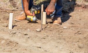
An aerial survey uses survey-grade drone systems to capture detailed site data from above. Instead of relying on guesswork, it records measurable elevation information across the entire property.
The process produces high-resolution imagery and accurate surface models. More importantly, it highlights small grade changes that signal erosion, settlement, or slope movement.
For instance, if runoff carved a shallow channel behind your home, the aerial survey will show it clearly. If soil shifted near a retaining wall, elevation data will reveal the difference. Because the information covers the full site, it provides a broader view than a ground walk-through ever could.
That comprehensive view explains why demand continues to rise after recent storm damage reports.
Developers and Builders Need Updated Data Fast
Storms disrupt construction schedules. Flooding can wash out compacted soil, fill trenches with debris, and change finished grades. When that happens, original site plans may no longer match real conditions.
Developers cannot afford to move forward blindly. Engineers need updated surface data before approving the next phase of work. Inspectors expect accurate documentation.
Therefore, many builders now order an aerial survey shortly after heavy rainfall. That step allows them to confirm elevations, adjust grading plans, and avoid costly delays.
Because construction projects depend on precision, fast and accurate site measurement protects both budgets and timelines.
Homeowners Want Answers Before Problems Grow
Homeowners often notice small warning signs first. Perhaps water pools near the foundation. Maybe a patio crack widens slightly. A fence may lean more than before.
Those signs create worry, yet they do not explain the cause. Did the slope shift? Did erosion remove supporting soil? Or did nothing serious happen?
An aerial survey provides clear data. It measures the land as it stands today. With that information, homeowners can consult engineers or contractors with confidence. Instead of guessing, they rely on measurable facts.
Moreover, early documentation helps prevent small concerns from turning into expensive repairs. When you understand site conditions right away, you can act sooner and smarter.
Insurance and Liability Concerns Drive Action
Storm damage often leads to insurance claims. However, claims require proof. Adjusters ask for documentation that shows measurable change.
An aerial survey strengthens that documentation. It records erosion areas, elevation differences, and drainage changes in a clear and professional format. If another storm hits later, you already have a baseline for comparison.
Because timing affects credibility, many property owners now schedule an aerial survey soon after a major storm rather than waiting for visible damage.
In addition, HOAs and commercial property managers use aerial data to reduce liability. If unstable slopes or altered drainage patterns exist, early identification allows for safer planning and corrective action.
Safety Matters When Soil Becomes Unstable
After heavy rain, slopes may not hold firm. Saturated soil can give way without warning. Sending crews to walk unstable ground increases risk.
An aerial survey reduces that exposure. Drone systems capture needed data without placing workers in dangerous areas. For canyon lots, steep hillsides, and coastal bluffs, that safety benefit becomes significant.
Because safety always comes first, many engineers now recommend aerial data collection before detailed ground inspection.
A Shift Toward Proactive Planning in San Diego
Recent storm events reminded many property owners that land can change quickly. Even when buildings appear intact, the ground beneath them may tell a different story.
As weather patterns grow less predictable, proactive documentation becomes more valuable. An aerial survey transforms uncertainty into measurable information. It allows homeowners, developers, and property managers to make informed decisions based on data rather than assumptions.
That shift explains the surge in demand. People no longer wait for visible failure. Instead, they choose to measure first and act with clarity.
When the land changes, the smartest response is to understand it from above. In San Diego, that understanding often begins with an aerial survey.