Recent research about rising sea levels has started new talks in coastal cities. Scientists now say the ocean may already be higher than earlier models showed. Because of this, more homes and properties could face flood risk in the future. For property owners, buyers, and developers, this news brings up an important question: How safe is my property really? That is where an elevation survey becomes very useful. While news stories talk about sea-level trends across large areas, an elevation survey focuses on one property. It shows exactly how high or low the land sits compared to nearby water and flood levels. Because of that, owners get clear information that helps them make smarter choices.
Why the New Sea-Level Study Matters to Property Owners
Sea-level studies usually look at large coastal areas. They estimate how rising oceans may affect cities over time. However, the new research suggests that some plans may underestimate the risk in certain places.
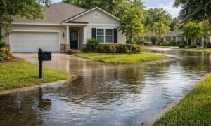
In simple terms, some properties could face flooding sooner than people expected.
Still, coastal neighborhoods are not all the same. One home may sit several feet higher than the house next door. Even small changes in height can affect how water moves during storms or heavy rain.
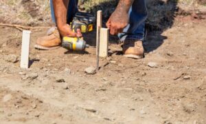
Because of this, relying only on general flood estimates may not give the full picture. Property owners need clear information about their own land, and getting accurate elevation data from a professional survey can help show exactly how a property sits compared to nearby terrain and water levels.
Why Property Decisions Now Depend More on Accurate Data
Buying or building near the coast has always involved risk. However, the new sea-level findings make many buyers and investors look more closely at property elevation before making a decision.
For example, imagine two houses located only a few blocks apart. At first, both properties may look very similar. Yet one sits a little higher above sea level. Because of that small difference, the higher property may face less flood risk during strong storms.
Without clear elevation data, it is hard to see these differences.
Because of this, many real estate professionals now suggest checking elevation early in the process. An elevation survey helps buyers compare properties with confidence instead of guessing.
How an Elevation Survey Supports Smarter Property Planning

When people hear about sea-level changes, they often think only about flooding. However, elevation also affects many other planning decisions.
For example, builders must understand how water will move across a site. If the land sits too low, water may collect around foundations or driveways. Over time, this can damage buildings or cause drainage problems.
However, when a project starts with an elevation survey, designers get the information they need to plan the site properly. They can adjust grading, drainage, and foundation height before construction begins.
Because of that early information, many costly problems can be avoided later.
Why Even Small Elevation Differences Can Matter
Most people think only large height changes cause problems. However, in coastal areas, even a few inches can matter.
For example, imagine a property that sits just below a nearby drainage path. During heavy rain, water may flow toward that lower spot. Meanwhile, a nearby lot that sits slightly higher may stay dry.
That small difference can affect building decisions. Builders may need to raise a foundation or improve drainage to protect the structure.
An elevation survey helps show these details before construction starts. Because of that, property owners have time to plan instead of dealing with surprises later.
Why This Is Especially Important in Coastal Cities
Coastal cities like San Diego offer beautiful views and easy access to the ocean. However, these areas also have many different land heights. Some homes sit on high bluffs above the water. Others sit in flatter neighborhoods closer to sea level.
Because of this, flood risk can change quickly within a short distance. One street may sit several feet higher than another just a few blocks away.
Because of this difference, property buyers often want to know how elevation affects their own lot. An elevation survey helps answer that question clearly. It shows how the property relates to nearby land, water, and flood levels used by planners and engineers.
When Property Owners Often Need an Elevation Survey
Many people only think about elevation after a problem appears. However, the best time to check elevation is usually earlier.
For example, buyers may request an elevation survey while looking at coastal property. This helps them confirm whether the site fits their plans.
Homeowners may also request one before starting a large renovation or rebuilding project. In that case, knowing the elevation helps designers plan foundations and drainage correctly.
Developers also rely on elevation surveys when studying possible building sites. Accurate elevation data helps them compare different lots and choose the one that works best.
Because of these reasons, elevation surveys often become part of smart property planning.
Why Acting Early Can Prevent Expensive Surprises
Many property projects start with excitement. Buyers imagine their future homes, and builders begin planning new designs. However, if elevation information appears too late, the project may suddenly change.
For example, a design may need changes if the land sits lower than expected. Drainage plans may need updates. In some cases, permits or approvals may take longer if planners ask for more elevation data.
Because of situations like this, many property owners start checking your property’s elevation before building, especially when planning construction near coastal areas. When an elevation survey happens early, these surprises rarely occur. Property owners understand their site from the beginning, so planning becomes smoother and easier.
Understanding Your Property in a Changing Coastal Environment
News about rising sea levels reminds everyone that coastal areas continue to change. Scientists study these trends to help cities prepare for the future. Still, every property sits in a different position within that larger landscape.
Because of that, site-specific information remains the best guide for owners and buyers.
An elevation survey helps provide that information. It measures how a property sits compared to nearby land and water levels. With this knowledge, property owners can move forward with greater confidence.
Final Thoughts
The new sea-level research has increased awareness about coastal flood risk. While the headlines focus on large global changes, each property has its own story.
An elevation survey helps reveal that story clearly. It gives buyers, homeowners, and developers accurate information about how their property sits within the surrounding land.
Because of that information, people can make better decisions before buying, building, or investing near the coast.
As coastal conditions continue to change, understanding elevation may become one of the most valuable steps a property owner can take.